
I must admit that when I started to deal with the clear evidence of heat transport into the Arctic, the global warming debate predisposed me to accept the obvious conclusion that the source of the heat was to be found in atmospheric science. This led me to pay far less attention to ocean currents than perhaps I should.
Another problem of course is that the data is terribly sparse.
My argument though is that it is not unreasonable at all for a simple shift in the parameters of surface waters to provide the necessary heat drivers to modify atmospheric conditions significantly. In order words, a small gain in contained heat translates into much more evaporation and that leads to much more heat release downwind on land.
Also a slight gain translates into a heat transfer into the Arctic that slowly erodes the base of the sea ice. Again the amount of actual change may even be hard to detect outside of normal error. Yet water holds an incredible amount of heat.
So we can make a conjecture that is presently supported by the observations. Sometime perhaps thirty years ago the global current flow was naturally modified causing a velocity change. I do not know how the modification took place, although the alteration of a small gyre associated with the southern polar currents and the global counter currents feels like a really good to look. My reasons for that are that at some point the surplus cold built up in the Antarctic needs to be transported out and this is a process that could well be multidecadal.
I posted a couple of year’s back that the one explanation for the sudden temperature decline of the Little Ice Age was the sudden injection of cold water into the South Atlantic. However the trigger may well be a build up of warm waters in the Arctic that naturally accelerates toward the switch point.
Once we dismiss the complication of attempting to explain atmospheric data and simply focus on water borne heat transport, difficulties disappear. We presently are receiving more heat into the Arctic than is been absorbed. It is arriving through the Gulf Stream. The heat supply is a constant but the velocity change the counter current suggests that more cold water is been removed. This has shifted the heat balance against the sea ice.
It is only now that the sea ice is thinned out to a season’s thickness that wind, wave and sun can accelerate the final breakup of the ice floes. It is no longer strong enough to resist.
A couple of things to recall when we discuss current flows that help make modeling challenging. Firstly, the energy from the sun falling on the ocean is so close to been a constant that it is. Thus year after year the energy supplied to the Atlantic is the constant A. Secondly the total water in the oceans is also a constant we may call O. What varies is the current flow, but most of that is driven primarily by the oceanic gyres and not at all by temperature, let alone surface temperature. This is all incredibly stable.
Another constant is the driving energy of all this which is the dynamic energy produced by the Earth’s spin.
So something changed the parameters of this global system rather slightly. The only forcer that I presently know about is the Antarctic Circumcurrents that likely grow and shrink over long time cycles in response to the powerful freezing power of the Antarctic.
It is reasonable that a cooling Antarctic would trigger a warming
What we need is a high resolution three dimensional map of the whole of the ocean. Some of it is easy, such as the main gyres. However regions in which currents pass each other is quite a different matter. There is ample room for the creation of smaller gyres there that act as change engines.
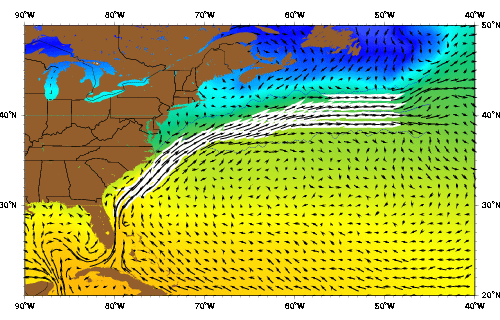
The Gulf Stream
Joanna Gyory, Arthur J. Mariano, Edward H. Ryan
http://oceancurrents.rsmas.miami.edu/atlantic/gulf-stream.html
The Gulf Stream as represented by the Mariano Global Surface Velocity Analysis (MGSVA). The Gulf Stream is the western boundary current of the N. Atlantic subtropical gyre. The Gulf Stream transports significant amount of warm water (heat) poleward. The averaging of velocity data from a meandering current produces a wide mean picture of the flow. The core of the Gulf Stream current is about 90 km wide and has peak velocities of greater than 2 m/s (5 knots). Click here for example plots of seasonal averages.
http://oceancurrents.rsmas.miami.edu/atlantic/img_mgsva/gulf-stream-YYY.gif
Beginning in the Caribbean and ending in the northern North Atlantic, the Gulf Stream System is one of the world's most intensely studied current systems. This extensive western boundary current plays an important role in the poleward transfer of heat and salt and serves to warm the European subcontinent. Traditional hydrographic studies in this region include those of Iselin (1936) and Gulf Stream '60 (Fuglister 1963). The high degree of mesoscale activity associated with this system also has attracted oceanographers. Studies of these phenomena have focused on the "snapshot" representation of the region and have included studies such as SYNOP, Gusto, and ABCE/SME. The Gulf Stream system is powerful enough to be readily seen from space and was visible in even the earliest satellite altimetry studies, such as Seasat and later Geosat. Strong thermal gradients also made it visible to infrared measurements, like VHRR (Very High Resolution Radiometer) readings using the early NOAA satellites, THIR (Temperature and Humidity Infrared Radiometer) readings from Nimbus satellites, and Advanced VHRR (AVHRR) readings from later NOAA satellites.
The Gulf Stream begins upstream of Cape Hatteras, where the Florida Current ceases to follow the continental shelf. The position of the Stream as it leaves the coast changes throughout the year. In the fall, it shifts north, while in the winter and early spring it shifts south (Auer 1987; Kelly and Gille 1990; Frankignoul et al. 2001). Compared with the width of the current (about 100-200 km), the range of this variation (30-40 km) is relatively small (Hogg and Johns 1995). However, recent studies by Mariano et al. (2002) suggests that the meridional range of the annual variation in stream path may be closer to 100 km. Other characteristics of the current are more variable. Significant changes in its transport, meandering, and structure can be observed through many time scales as it travels northeast.
The transport of the Gulf Stream nearly doubles downstream of Cape Hatteras (Knauss 1969; Hall and Fofonoff 1993; Hendry 1988; Leaman et al. 1989) at a rate of 8 Sv every 100 km (Knauss 1969; Johns et al. 1995). It appears that the downstream increase in transport between Cape Hatteras and 55°W is mostly due to increased velocities in the deep waters of the Gulf Stream (Johns et al. 1995). This increase in velocity is thought to be associated with deep recirculation cells found north and south of the current (Hall and Fofonoff 1993). Examples of these recirculations include small recirculations east of the Bahamas (Olson et al. 1984; Lee et al. 1990), the Worthington Gyre south of the Gulf Stream between 55° and 75°W (Worthington 1976), and the Northern Recirculation Gyre north of the Gulf Stream (Hogg et al. 1986). Recent studies suggest that the recirculations steadily increase the transport in the Gulf Stream from 30 Sv in the Florida Current to a maximum of 150 Sv at 55°W (Hendry 1982; Hogg 1992; Hogg and Johns 1995).
The Gulf Stream transport varies not only in space, but also in time. According to Geosat altimetry results, the current transports a maximum amount of water in the fall and a minimum in the spring, in phase with the north-south shifts of the its position (Kelly and Gille 1990; Zlotnicki 1991; Kelly 1991; Hogg and Johns 1995). Rossby and Rago (1985) and Fu et al. (1987) obtained similar results when they looked at sea level differences across the Stream. All of these studies found that the Gulf Stream has a marked seasonal variability, with peak-to-peak amplitude in sea surface height of 10-15 cm. The fluctuation is mostly confined to the upper 200-300 m of the water column and is a result of seasonal heating and expansion of the surface waters (Hogg and Johns 1995). Height differences this small, if assumed to decay linearly to zero at 300 m, would only result in annual transport fluctuations of about 1.5 Sv (Hogg and Johns 1995).
Interestingly, the variations in transport of the deep waters in the current appear to be almost opposite in phase to the surface waters, and their magnitude is more significant (Hogg and Johns 1995). As Worthington (1976) suggested, the maximum transport occurs in the spring, and the amplitude of the annual cycle is as large as 5-8.5 Sv (Manning and Watts 1989; Sato and Rossby 1992; Hogg and Johns 1995). The mechanism Worthington proposed was extensive convection south of the Gulf Stream in winter due to the atmospheric cooling of surface waters. This causes the thermocline to deepen and the baroclinic transport to increase (Fu et al. 1987). Although his idea has been controversial, alternate hypotheses have not adequately explained observations (Hogg and Johns 1995).
Like transport, the meandering of the Gulf Stream intensifies downstream of Cape Hatteras, reaching a maximum near 65°W. Meanders often pinch off from the current to form Gulf Stream rings. On average, the Stream sheds 22 warm-core rings and 35 cold-core rings per year (Hogg and Johns 1995).
Once it reaches the Grand Banks, the structure of the Gulf Stream changes from a single, meandering front to multiple, branching fronts (Krauss 1986; Johns et al. 1995). Early oceanographic papers on the North Atlantic (Iselin 1936; Fuglister 1951a, 1951b; Sverdrup et al. 1942) mention the branching, but due to sparse data in this area, the branch points were considered largely theoretical until confirmed by Mann (1967). Mann (1967) showed two branches at 38°30;N 44°W. One branch curves north along the continental slope, eventually turning east between 50° and 52°N. This branch is called the North Atlantic Current and was well known even in Iselin's time. The other branch flows southeastward towards the Mid-Atlantic Ridge and is called the Azores Current. This southern branch is most likely synonymous with Iselin's "Atlantic Current" and was formally named the Azores Current in a paper by Gould (1985).
The region of the Gulf Stream's branch point is highly dynamic and subject to rapid change. The high degree of mesoscale activity, along with rapid changes in the major surface currents, make this a very difficult region to study. Part of this variability arises from the high amount of eddy activity. Eddy kinetic energy along both the Gulf Stream and the North Atlantic Current is at peak values here (Richardson 1983). There is also the presence of elongated, high-pressure cells along the offshore side of the North Atlantic Current (Worthington 1976; Clarke et al. 1980; Baranov and Ginkul 1984; Krauss et al. 1987). These pressure cells may be linked to outbursts of Labrador Current water from the Grand Banks (Krauss et al. 1987) that lead to extensive mixing at the end of the Gulf Stream.
References
Auer, S.J., 1987: Five-year climatological survey of the Gulf Stream System and its associated rings. Journal of Geophysical Research, 92, 11709-11726.
Baranov, E.I., and V.G. Ginkul, 1984: Dynamics of waters of the Newfoundland energy active zone. Meteorologiya di Gidrologiya, 12, 78-84.
Clarke, R.A., H.W. Hill, R.F. Reiniger, and B.A. Warren, 1980: Current system south and east of the Grand Banks of Newfoundland. Journal of Physical Oceanography, 10, 25-65.
Frankignoul, C., G. de Coetlogon, T.M. Joyce, and S.F. Dong, 2001: Gulf Stream variability and ocean-atmosphere interactions. Journal of Physical Oceanography, 31, 3516-3529.
Fu, L.L., J. Vazquez, and M.E. Parke, 1987: Seasonal variability of the Gulf Stream from satellite altimetry. Journal of Geophysical Research, 92, 749-754.
Fuglister, F.G., 1951a: Annual variations in current speeds in the Gulf Stream System. Journal of Marine Research, 10, 119-127.
Fuglister, F.G., 1951b: Multiple currents in the Gulf Stream System. Tellus, 3, 230-233.
Fuglister, F.G., 1963: Gulf Stream at 60. Progress in Oceanography, 1, 265-373.
Gould, W.J., 1985: Physical Oceanography of the Azores Front. Progress in Oceanography, 14, 167-190.
Hall, M.M., and N.P. Fofonoff, 1993: Downstream development of the Gulf Stream from 68° to 55°W. Journal of Physical Oceanography, 23, 225-249.
Hendry, R.M., 1982: On the structure of the deep Gulf Stream. Journal of Marine Research, 40, 119-142.
Hendry, R.M., 1988: A simple model of the Gulf Stream thermal structure with application to analysis of moored measurements in the presence of mooring motion. Journal of Atmospheric and Oceanic Technology, 5, 328-339.
Hogg, N.G., 1992: On the transport of the Gulf Stream between Cape Hatteras and the Grand Banks. Deep-Sea Research, 39, 1231-1246.
Hogg, N.G., R.S. Pickart, R.M. Hendry, and W.J. Smethie Jr., 1986: The Northern Recirculation Gyre of the Gulf Stream. Deep-Sea Research, 33, 1139-1165.
Hogg, N.G. and W.E. Johns, 1995: Western boundary currents. U.S. National Report to Internatonal Union of Geodesy and Geophysics 1991-1994, Supplement to Reviews of Geophysics, 33, 1311-1334.
Iselin, C.O'D., 1936: A study of the circulation of the western North Atlantic. Papers in Physical Oceanography and Meteorology, 4, 101 pp.
Johns, W.E., T.J. Shay, J.M. Bane, D.R. Watts, 1995: Gulf Stream structure, transport, and recirculation near 68° W. Journal of Geophysical Research, 100, 817-838.
Kelly, K.A., 1991: The meandering Gulf Stream as seen by the Geosat altimeter: surface transport, position and velocity variance from 73° to 46°W. Journal of Geophysical Research, 96, 16721-16738.
Kelly, K.A., and S.T. Gille, 1990: Gulf Stream surface transport and statistics at 69°W from the Geosat altimeter. Journal of Geophysical Research, 95, 3149-3161.
Knauss, J.A., 1969: A note on the transport of the Gulf Stream. Deep-Sea Research, 16 (Suppl.), 117-123.
Krauss, W., 1986: The North Atlantic Current. Journal of Geophysical Research, 91, 5061-5074.
Krauss, W., E. Fahrbach, A. Aitsam, J. Elken, and P. Koske, 1987: The North Atlantic Current and its associated eddy field southeast of Flemish Cap. Deep-Sea Research, 34, 1163-1185.
Leaman, K.D., E. Johns, and T. Rossby, 1989: The average distribution of volume transport and Potential Vorticity with temperature at three sections across the Gulf Stream. Journal of Physical Oceanography, 19, 36-51.
Lee, T.N., W. Johns, F. Schott, and R. Zantopp, 1990: Western boundary current structure and variability east of Abaco,
Mann, C.R., 1967: The termination of the Gulf Stream and the beginning of the North Atlantic Current. Deep-Sea Research, 14, 337-359.
Mariano, A.J., T.M. Chin and E.H. Ryan, R. Kovach and O.B. Brown, 2002: On Gulf Stream Path Variability. J. Physical Ocean., (submitted).
Manning, J.P., and D.R. Watts, 1989: Temperature and velocity structure of the Gulf Stream northeast of Cape Hatteras: Modes of variability. Journal of Geophysical Research, 94, 4879-4890.
Olson, D.B., F.A. Schott, R.J. Zantopp, K.D. Leaman, 1984: The mean circulation east of the Bahamas as determined from a recent measurement program and historical XBT data. Journal of Physical Oceanography, 14, 1470-1487.
Richardson, P.L., 1985: Average velocity and transport of the Gulf Stream near 55°W. Journal of Marine Research, 42, 83-111.
Rossby, H.T., and T. Rago, 1985: Hydrographic evidence for seasonal and secular change in the Gulf Stream. IOC Technical Report, 30, 25-28.
Sato, O.T., and T. Rossby, 1995: Seasonal and low frequency variations in dynamic height anomaly and transport of the Gulf Stream. Deep-Sea Research, 42, 149-164.
Sverdrup, H.U., M.W. Johnson, and R.H. Fleming, 1942: The Oceans, 1087 pp. Prentice Hall, Englewood Cliffs, NJ.
Worthington, L.V., 1976: On the North Atlantic circulation. Oceanographic Studies, The
Zlotnicki, V., 1991: Sea level differences across the Gulf Stream and Kuroshio Extension. Journal of Physical Oceanography, 21, 599-609.
No comments:
Post a Comment